Bandaaje Arbi Waterfall
Bandaaje / Bandaje Arbi falls |
About: |
|
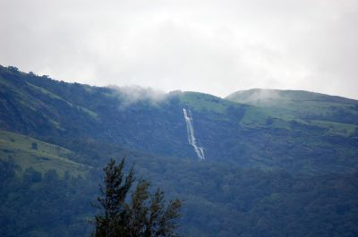
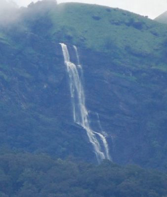
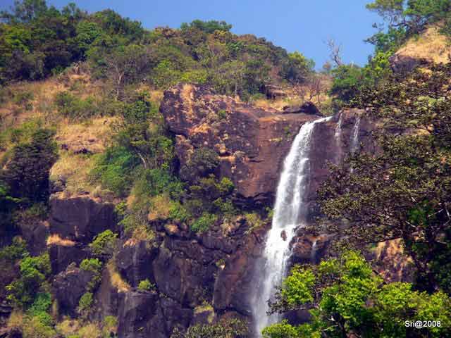
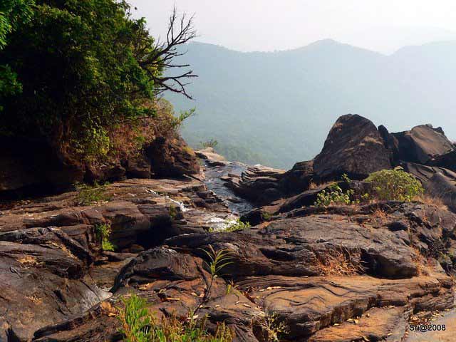
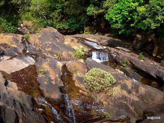
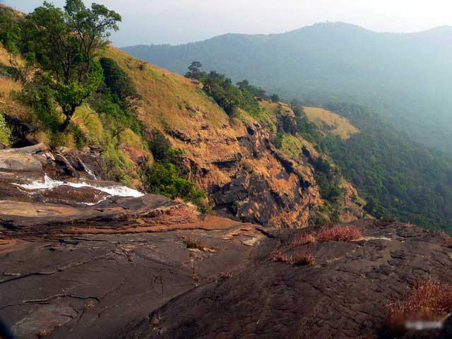
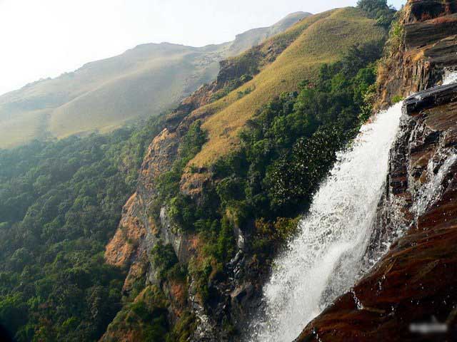
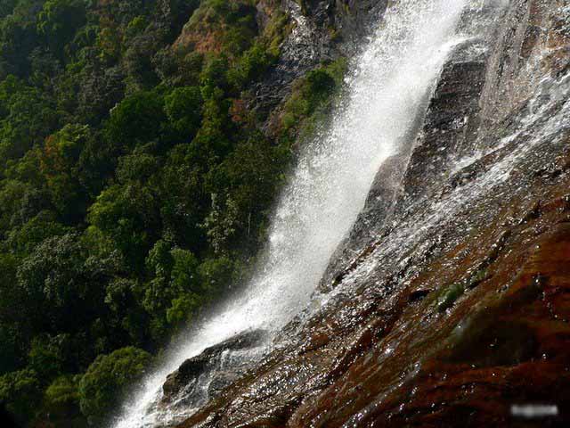
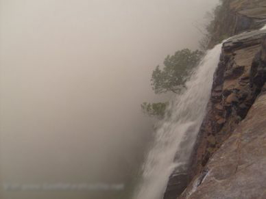
Bandaaje Arbi Falls, one of the beautiful waterfalls in the Western Ghats, is located near Mundaaje, in Dakshina Kannada District of Karnataka. It cascades down from a height of 200 ft. You would have heard of an adage that says,'the journey is more significant than the destination itself'. Taking a trip to reach the Bandaje Arbi waterfall is a best example of this saying. Reaching this scenic spot has no particular set path. Based on individual inclinations, the easy path can be easily accessible. While the tougher, more eventful trail is open to those who dare. The South Kanara district lodges many waterfalls in the lush green mountains of the Western Ghats. One of them is the Bandaje Arbi falls in the Charmadi Ghat. Falling from a height of around 200 feet, the route to reach this Arbi, (which literally translates to waterfall in Kannada) is interesting. Visiting the waterfall is inevitably accompanied with trekking to or from the Ballala Rayana Durga fort. This is one of the routes popularly known for many people losing their way. Usually leading them to spend a night in the beautiful, creaking rain forests or in the humble cave, that is lodged near the waterfall. Therefore it is best to always come prepared with equipment (such as tents, sleeping bags, food and water supplies, etc.) Another pointer that would help is to keep you ears glued to the roaring sound of the waterfall. Following this thunderous guide will surely help, but you also need to have your acoustics in place to avoid the misleading waves that bounce off trees and mountains. Bandaaje Arbi One of the numerous waterfalls of the Western Ghats. This beautiful waterfall is at few kilometers distance from Mundaaje near Dharmasthala in South Kanara. Arbi is a 200+ft waterfall,but the path leads to the top of it. Ballalarayana Durga is visible from the topmost point of the hill about an hour's walk up from arbi. Arbi is waterfall in KannaDa. This waterfall can also be reached by sunkasaale and Ballalarayana Durga. Going by the amount of junk there,it seemed to be a popular spot. Its a pity to see such spots being polluted. More terrifying factor is the ignorance we prevail. Bandaaje Arbi Falls, one of the breathtaking waterfalls in the Western Ghats, is located near Mundaaje, in Dakshina Kannada District of Karnataka. It cascades down from a height of 200 ft. Ballalarayana Durga is visible from the topmost point of the hill about an hour's walk up from arbi. This waterfall can also be reached by sunkasaale and Ballalarayana Durga. |
Location info: |
| Address: |
| District: |
| Nearest City: Mundaaje is the nearest village, Ujire and Dharmasthala are the nearest towns. |
|
Best time to visit: Any time throughout the year The best time to visit is after the rains around end September, early October. At this time the forest has been washed clean and shines bright for your arrival, while the waterfall gushes at full strength roaring you to its embrace. The weather is neither too hot and sticky, nor too wet and cold. You could also trek in this place during March and April just before peak summer. However, be prepared sweat soaked walk as the humidity is relatively high. If you love chasing the rains and would like to volunteer for a monsoon trek, you may visit the waterfalls in the months of June and July. Only meant for adventurous souls, it is during this season the rains wash down trails and stir up the leeches. |
Climate/Weather: |
|
Maximum and minimum temperatures range between:- 36°C and 20°C in summers - March to May 27°C and 17°C in winter - December to February The monsoon is quite heavy and downpours in rain forests only dampen plans of camping. It is usually between June to September and October to November. |
History: |
Interesting things to do: |
|
Trekking Adventurous souls could discover their own routes when trekking. However the one of the possible routes could be:-
Events The Manjunatha Temple in Dharmasthala has its grand Deepotsava festival in November and December which attracts crowds from all over every year. Shopping info You may find religious artefacts at the temples in Horanadu and Dharmasthala. |
Interesting things to Visit: |
|
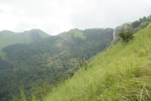
Besides the waterfall, one of the other major attractions is the Ballala Rayana Durga fort. Should you stop to smell the flowers or enjoy the scenic view the grasslands offer, you will reach the fort in 2 hours. The fort was built by the Hoysala Kings. But all that remains is a dilapidated 100 square metre space of trees and fortifications. However, do not miss the splendid scene from the fort towers. It presents a 360 degree view of the Shola forest, the Oorikan Estate to the east and the valley leading to Sunkasale below. Another major attraction is the amazing drive through the ghats. The pleating mountains that form a never ending horizon are breathtaking. The golden sunset, paints a peaceful hue on the rippling mountain range making this trip worth every effort. |
Mobile range info: |
How to reach? |
| Nearest Railway Station:Dharmastala |
| Nearest Airport:Mangalore Airport |
|
Road Transport:From Bangalore 350 kms The Western ghat ranges offer incomparable scenes and horizons, which are considered to be the best in South India. This picturesque journey is also accompanied with the winding road, which can be endured only by tough travellers with spines of steel. From Bangalore, one of the routes you could take is: Bangalore -(190 km)-> Hassan -(60 km)-> Belur - Chikkamagalur -(30km)-> Mudigere -(20 km)-> Kottigehara -(15 km)-> Sunkasale (Destination) Note:
By Bus From Bangalore, there are overnight Karnataka State Road Transport Corporation (KSRTC - http://ksrtc.in/) buses to Dharmasthala. Private bus services are available too. From Dharmasthala, state transport or private buses are available to Mundaaje (16 kms) or to Sunkasale (83 kms) For return journey from Sunkasale, there are buses to Bangalore from Dharmasthala via Kothigehara or from Horanadu via Kalasa, which can make up for another short tour! By Train There are no trains that connect Bangalore with any of the nearest villages or towns. The hilly terrain of the Western Ghats are connected well by road and usually travellers use bus services. Road Quality Due to road construction especially in the stretch between Hassan and Bangalore, the roads are in bad condition. During monsoons beware of potholes as the accident rates are high. Pictures of Bandaje ArbiBy Road: Bandaje Arbi falls is 350 km from Bangalore and takes almost 7 hours to reach there. Bandaje Arbi falls is about 25 Kms from Dharmasthala in South Kanara district. A state transport or private bus from Dharmasthala to Mundaaje (16kms) or to Sunkasaale (83kms) can be the starting point of the route Location:- Bandaje Arbi falls is 25+Kms from Dharmasthala in South Kanara district. |
Nearest Visiting places: |
|
Other places of interest nearby are : Ballala Rayana Durga. Buses are available from Dharmasthala to reach here. Ballalarayana Durga - one of the beautiful hilltops in the Western Ghats - is nearby. |
Nearest Petrol Pump: |
Hotels/Lodge/Accommodation: |
|
Where to stay :- Dharmasthala
|
Things to carry: |
|
Your backpack consisting of the following is recommended:-
Dealing with leeches
|
Tips & Suggestions: |
|
Things to Avoid Unless you are a dare devil, avoid visiting this place during peak monsoons. Avoid going alone or without a guide, as chances of getting lost are high. Also watch out for leeches and swarms of insects usually found near the fort.
|
Help Line/Phone Number: |
| Police Station:Belthangady Police Station - Tel: (08256)-232093 |
|
Nearest Hospital: The nearest hospital is located 8kms away in Ujire. You could also contact hospitals in the Belthangady district:-
|
|
Society/Community Phone Number Tourist offices:- KSTDC(bookings and info) Badami House, NR Square, Bangalore Tel: 080-2275869, Fax: 2352626 Email: kstdc@vsnl.in |
Bandaaje Arbi Falls Nearest Attraction |
| Nethrani Island |
| Nethrani is a small uninhabited island, 18 km southwest off a small fishing village Murdeshwar and is shaped like a upturned boat with some vegetation along the rocky outcrop. The Island is famous for its Shiva temple and for having some of the best dive sites in world....more |
| Kumaradhara River |
| The Kumaradhara River is an Indian river, in the southwestern India state of Karnataka. One of the two major rivers of Sullia, it merges with the Netravati River at Uppinangadi before flowing to the Arabian Sea.....more |
| Shambavi River |
| Shambavi is name of the river which flows in Dakshina Kannada district of Karnataka state, India. Mulki town is south of river Shambavi. The river flows westwards to join the Arabian sea. Bappanadu Durga temple is situated near the river.....more |
| Mukka Beach |
| Mukka is suburb of Mangalore city on the shore of Arabian sea. It is located to north of NITK,Surathkal campus on National Highway 17. There is a beach in Mukka which has escaped public attention....more |
| Panambur Beach |
|
Panambur is the site of New Mangalore Port. It is located in Dakshina Kannada (formerly South Canara ) district of Karnataka state, India, north of the Gurupura river.There is a Nandaneshwara temple in Panambur.....more |
| Someshwar Beach |
| Someshwar Beach, blessed with an endless stretch of golden sand and graciously swaying palm trees, is located 9 km south of Mangalore. The beach is well known for a large rock called 'rudra shila'.....more |
| Surathkal Beach |
| Located 15 km north of Mangalore, Suratkal Beach is known for its clean surroundings and a lighthouse. An uninterrupted and extremely attractive stretch of curving shoreline is a major feature of this beach. Sadashiva Temple is a nearby attraction.....more |
| Tannirubhavi Beach |
| Tannirubhavi beach is a beach in Mangalore, Karnataka, India. Currently, it can only be reach by land via Panambur or by ferry via Gurupura river from Sultan Battery.....more |
| Ullal Beach |
| Ullal Beach is situated about 12 km away from Mangalore on the south bank of the Nethravati River, facing Arabian Sea. Mangalore is a city of vivid contrasts. Apart from this beach, there are other beaches also in Mangalore.....more |
| Dharmasthala Temples |
| Dharmastala kshetra is located amongst the scenic beauty of the Western Karnataka on the banks of the Nethravathi River. The temple of Lord Manjunatha at Dharmastala is the star attraction in the Karnataka. ....more |
| Kadiri Temples |
| The 17th century Manjunath Temple is situated at the foot of the Kadiri Hill, 3 km north of Mangalore city. The temple has some superb bronze images of Buddha, dating to the 10th - 11th centuries. The idol of Lord Manjunathaswamy of the temple is believed to be the oldest of the South Indian Temples.....more |
| Katil Temples |
| The Name KATEEL: The word 'Kati' which means 'center' (between the 'Kanakagiri', birthplace of river Nandini and the end) and 'lla' which means 'area'. Thus the place is called 'Kati + lla' = Kateel. Kateel or Kateelu is a temple town in the Dakshina Kannada district of Karnataka, India. It is about 29 kilometers away from Mangalore and is considered one of the holiest temple towns in Hinduism.....more |
| Subramanya Temples |
| Kukke Subrahmanya Kshetra lies in the luxurious abundance of the beauty of the nature nature with rivers, forests and mountains in Sullia Taluk of Dakshina Kannada (South Canara) District. Kukke Subrahmanya Temple is regarded as one of the seven Mukti stala pilgrimage sites of Karnataka. (Kollur, Udupi, Kumbasi, Kodeshwara, Sankaranarayana and Gokarna are other Mukti places)....more |
| Mangalore Archeology |
| This temple is at the foot of the Katri hills, north of Mangalore. It is full of pilgrims. The temple belongs to the 10th century, but the pyramid like tower belongs to another time....more |
| Mangalore Historicals |
| Situated in the Western Ghats of Karnataka, Mangalore is one of the important centers of exporting coffee and cashew nut. It is a hilly city with winding disoriented streets located some 357 km away from the city Bangalore....more |
| Mudabidri |
| Mudabidri is another Jain town on par with Shrvanabelagola. It is 35 km from Mangalore. In this small farming town, there are 18 jain temples.....more |
| Alekan Waterfalls |
| Alekan is one of the attractive waterfalls in Dakshina Kannada District of Karnataka. It is noted for its picturesque locale. Bale Kallu Gudda - one of the highest hills in Dakshina Kannada District - is nearby. A winding scenic journey from Charmadi, 18 km away, takes to Alekan Waterfalls. Alekan Waterfalls is roughly four kilometers from kottigehara.....more |
| Dondole Falls |
| Dondole waterfalls is a nice water falls which is around 20 kms from a place called Kakkinje which is just 3kms before charmadi from Ujire. Part of this 20 kms can be covered in a jeep and after a rivercrossing and 50minutes of walk through the forest one reaches this waterfall which is of around 50+ft height.....more |
| Chakra River |
| Chakra is a west flowing river which originates east of Kodachadri in Shimoga District. This river basin has a catchment area of 336 sq km. The sub tributary of Chakra River is Kollur. Chakra River, the important source of irrigation in Karnataka, has a total length of 52 km....more |
SELECT YOUR HOLIDAY DESTINATION
-
Aero Sports in Karnataka
-
Archaeology in Karnataka
-
Beaches in Karnataka
-
Bird Sanctuaries in Karnataka
-
Bouldering Spot in Karnataka
-
Camping in Karnataka
-
Cave Explorations in Karnataka
-
Culturals Place in Karnataka
-
Dams in Karnataka
-
Districts Of Karnataka
-
Fairs in Karnataka
-
Festivals in Karnataka
-
Go-Karting in Karnataka
-
Hill Stations in Karnataka
-
Historical Places in Karnataka
-
Holiday Resorts in Karnataka
-
Islands in Karnataka
-
Landscape in Karnataka
-
Mountain Biking in Karnataka
-
National Parks in Karnataka
-
Orbit Network
-
Pilgrims Destinations
-
Para-sailing in Karnataka
-
River rafting in Karnataka
-
Rivers in Karnataka
-
Rock Climbing in Karnataka
-
Safari in Karnataka
-
Temples in Karnataka
-
Trekking in Karnataka
-
Water Sports in Karnataka
-
Waterfalls in Karnataka
-
Wildlife Sanctuaries in Karnataka