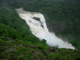
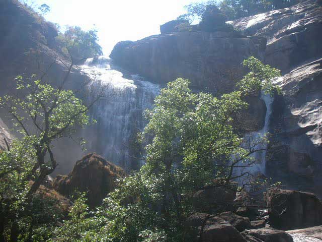
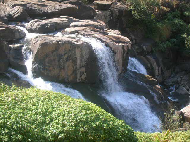
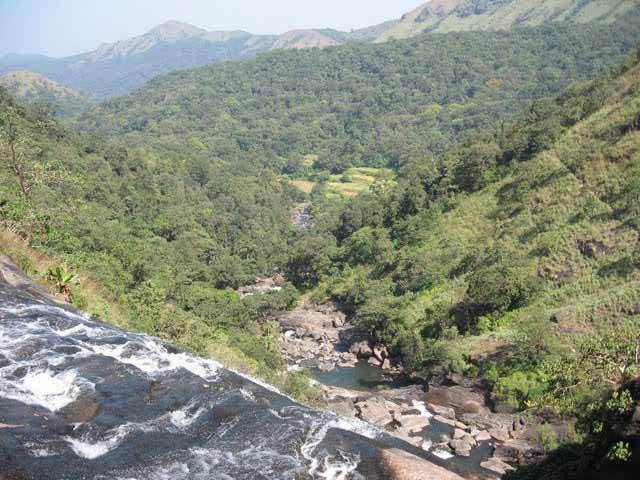
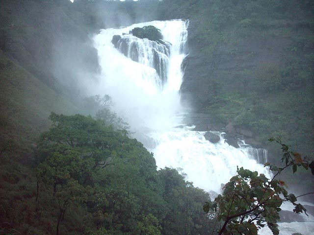
Mallalli Waterfall
Mallalli falls |
About: |
|
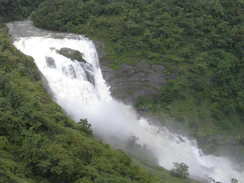
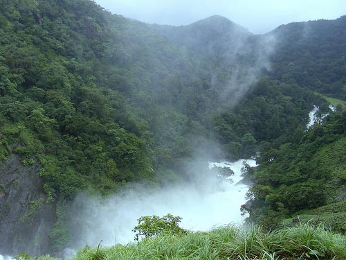
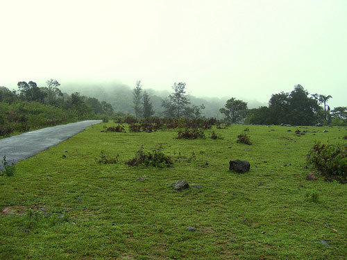
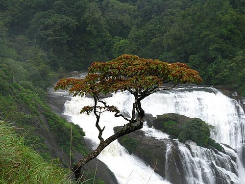
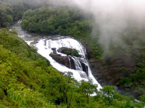
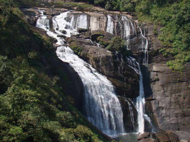
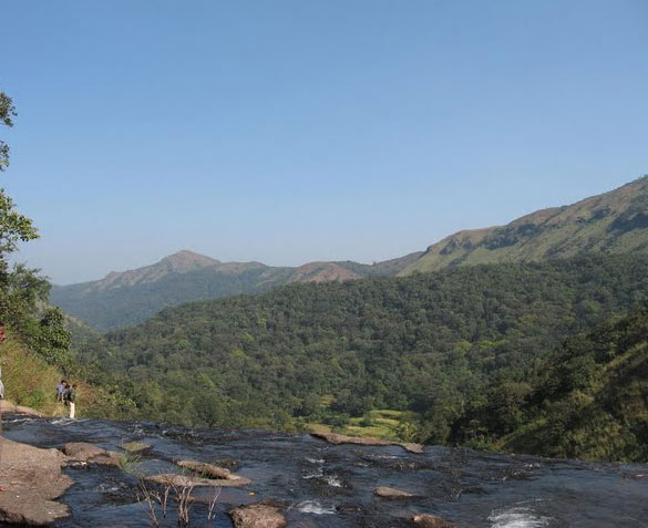
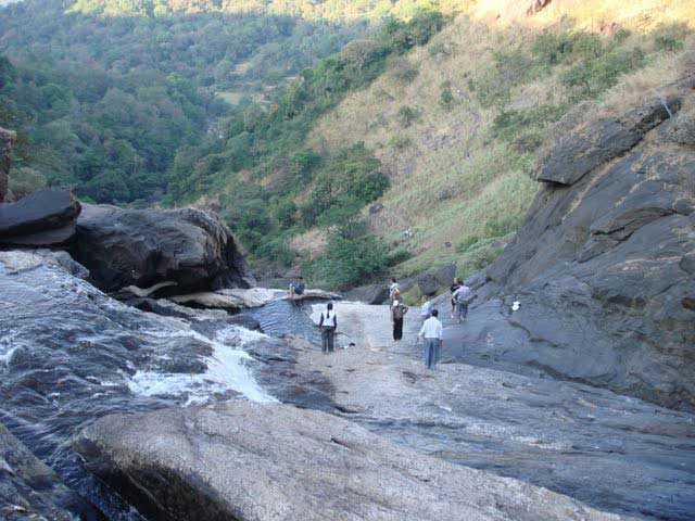
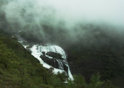
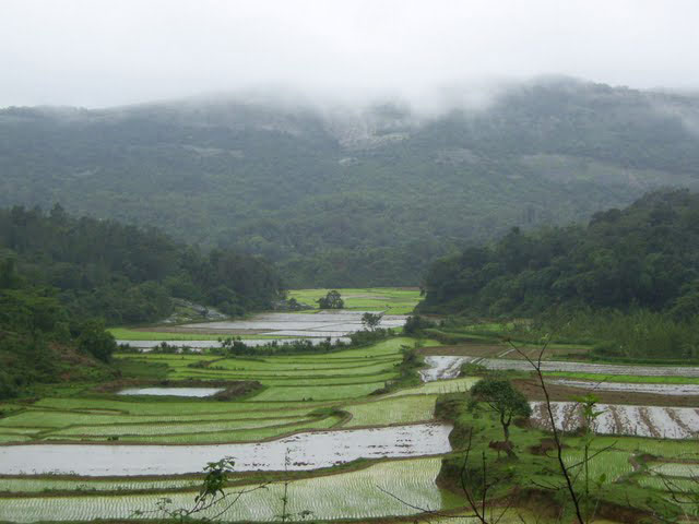
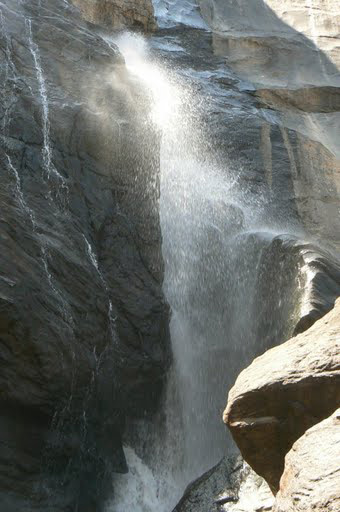
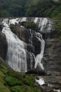
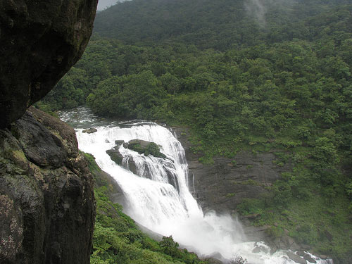
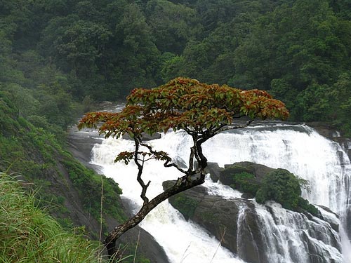
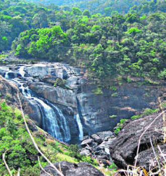
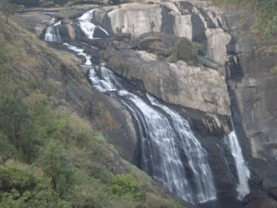
Mallalli falls is situated in the foots of pushpagiri hills. It in about 18 kms from somwarpet, the falls is 2 kms inside the main road. Mallalli Falls is situated in Coorg and is around 25 kms from Somwarpet and 260 kms from Bangalore. The exact location of Mallali falls is in Bettadahalli Gram Panchayat in Somwarpet of Coorg. It's is an eye feasting sight of river Kumaradhara gushing through the valley and falling into a gorge, with lush green mountains around. Mallalli falls, Kumaradhara river, around 30 KMs from Somawarapet and approximately 275 KMs from Bangalore. To reach Mallalli falls, one has to take a deviation at Hanchinalli. Hanchinalli comes 2 KMs before Beedalli when travelling from Somavarpet towards Beedalli. From Hanchinalli it's a bumpy jeep track for 2 to 3 KMs. And then a walk for almost a kilometer. It was completely misty even at 11 in the morning. End of wonderful walk brought us to the view point which gives us a majestic view of the falls. Though we had lots of time, we decided not to go down to the foot of the falls as it was very slippery on the rocks. RIVER : KUMARADHARA |
Location info: |
| Address: |
| District: |
| Nearest City: |
| Best time to visit: Between December to January |
Climate/Weather: |
History: |
Interesting things to do: |
Interesting things to Visit: |
Mobile range info: |
How to reach? |
| Nearest Railway Station: |
| Nearest Airport: |
| Road Transport: |
Nearest Visiting places: |
|
Abby Falls About 8 Kms from Madikeri is the beautiful waterfall and picnic spot, where the Abbey cascades 70 ft down to flow as a small river. A path through coffee and cardamom plantation off the main road adds to the attraction of the perennial waterfall. Enjoy the gushing, roaring beauty but a desire to take a dip in the cool waters may prove to be risky. This is a well known pilgrimage centre situated at a distance of 39 kms from Madikeri. Bhagamandala is on the banks of the confluence of three rivers, Cauvery, Kannike and the sub terranian Sujyoti, popularly known as "Triveni Sangama". The famous Sri Bhagandeswara temple is located here. A large number of tourists visit Bhagamandala particularly during the Thula Sankramana jatra and the entire Thula month (October-November). Gandhi Mantap A memorial to the father of the nation built at the site where Mahatma Gandhi sat and addressed the people of Madikeri during his visit in 1932. Gaddige Gaddige or the tombs of Virarajendra and Lingarajendra at Madikeri is one of the important monuments of Coorg. The royal tombs on a hillock to the north of Madikeri provide a commanding view of the town. Lingarajendra's tomb was built in 1820. There are also the tombs of a Raja's priest and that of two army commanders. A commemorative plaque, eulogizing the bravery of General Biddanda Bopu who fought. Tipu Sultan has been recorded by Dodda Veerarajendra in an inscription. The tombs are in the style of Muhammadan edifices with domes in the center and turrets at the angles. The bars of windows made of brass have fine engravings. The grounds surrounding the tombs have been encroached. Omkareshwara Temple This temple built by Lingaraja in 1820 is a perfect blend of Islamic and Gothic styles of architecture. The temple is dedicated to Lord Siva, and the Siva Linga brought from Kashi````````` (Varanasi) has been installed here. Legend has it that the king built the temple to absolve himself of his wrong doings.
Perched a top a hill, overlooking a wide valley is the place where the kings of you are spent their evenings, watching the spectacular sunset and mesmerizing view of the valley around. An early morning visit, bracing the chilly breeze gives a glimpse of the hilltops rising above the mist-covered valley to kiss the sky. Next to this beautiful park is the 300year old temple of Kundurumotte Chowti Mariamma. Talacauvery Talacauvery is the birthplace of the sacred river Cauvery. It is situated on the slopes of the Brahmagiri Hills, and can be reached by a motorable road from Bhagamandala, which is at a distance of 8 kms. There are temples dedicated to Ishwara & Ganapathi at the source of Cauvery. The "Tula Sankramana" day (usually falling in the month of October) is regarded as the most auspicious day for visiting Talacauvery. There is a small square tank (Cauvery Kundike) by the side of a fairly big tank in Talacauvery, which is the source of the river. It is believed that on the day of the "Tula Sankramana", at an auspicious moment, the holy Cauvery appears, and that her arrival is indicated by a sudden upsurge of the water in the pond. Near the source of Cauvery one can climb up about 300 feet to the summit of the Brahmagiri peak where, it is said, the seven great sages meditated. From the top of the hill one can feast his eyes with splendid display of nature. Apart from its importance as a centre of pilgrimage Talacauvery is an ideal place for a visit by any tourist, for its natural beauty. The Fort The fort is situated in the center of the town, on top of a hillock. Built by Lingaraja during the 19th century, now it houses the state government offices, the law courts and the public library. The ancient Ganesha temple, the statue of two elephants, the stone turtle in the courtyard is reminiscent of history. A Chapel built by the British after the accession in 1834 houses a museum. A visit to this museum will give an insight into the history of Kodagu. Cauvery Nisarga Dhama Forest department is maintaining this wonderful picnic spot, on the banks of river Cauvery, near Kushalnagar. The hanging bridge, pedal boat center, tree top shelters, elephant safari, deer park is the main attractions of Cauvery Nisargadhama. Forest Department provides bamboo cottages and brick cottages for tourists. Situated at a distance of 2 kms from Kushalnagar on the Mysore-Madikeri Road. This is a man-made island with an area of 65 acres. It has huge hanging bridge at the entrance of this spot. Dubare Forest Another picnic spot near Kushalnagar on the banks of river Cauvery. Elephant training camp belonging to forest department is situated here. River Cauvery comes under Mahasheer fishing area, supported by Coorg Wild Life Society. This island situated near Kushalnagar is not connected by public transport. Hire a taxi from Kushalnagar. Harangi A reservoir with picturesque spot is one of the main attractive tourist centre at a distance of 9 kms from Kushalnagar. Best season to visit is between August and December. Private buses are available or you can hire a taxi from Kushalnagar. Golden Temple Gautam Buddha at India's biggest Tibetan monastery covered from coorg. This comprises of two universities and two monasteries and is inhabited by Tibetian Monks. This is situated near kushalnagar, 30 Kms from Siddapura and known as "Byle Kuppe". Bylukuppa, a nearby village of Kushalnagar (belongs to Mysore district) houses refugees from Tibet. Although refugees, Tibetians have kept their culture and heritage intact. Tourists can witness their way of life, architecture; even taste Tibetian dishes and Tibetian handicrafts are also available. Regular buses operate from Kushalnagar to Periyapatna via Bylukuppa. Bramhagiri Line of Hills Brahmagiri is a mountain range in the Western Ghats of south India. It is situated on the border between Wayanad District of Kerala state on the south and Kodagu district in Karnataka on the north side. Brahmagiri Hill, at 1608 m height, is a scenic tourist attraction. Thirunelli Temple, dedicated to Lord Vishnu, lies on the Kerala side of Brahmagiri. This temple is known as Dakshina Kashi or the Kashi of the South. The temple constructed in an ancient style and includes 30 granite pillars. According to legend, the temple was constructed by Lord Brahma himself. Irupu (or Irpu or Lakshmana Tirtha) Falls of the Lakshmana Tirtha river lies on the Karnataka side of Brahmagiri. According to legend, when Rama and Lakshmana were searching for Sita, they became thirsty. Lakshmana shot an arrow into the Brahmagiri from which the river sprang. Rama is said to have dedicated a Shiva Kshethra known as Rajeshwara Temple on the banks of river Lakshmana Tirtha. The Lakshmana Tirtha river eventually flows into the Kaveri River. Brahmagiri can be reached by a trek from Mananthavady (29 km east) or from Kutta. From Karnataka side, trek to Brahmagiri from Irpu Falls is 9 km and to Munikal Caves is 7 km. Trekkers need to seek the permission of Range Forest Officer at Srimangala. Another Wildlife Sanctuary near Nagarahole National Park. Irupu Rameshwara Temple and Irupu Falls are situated nearby. As the mountain comes under Brahmagiri Wildlife Sanctuary area, prior permission from the Department of forests in necessary. Trekking distance 24 kms; 80 kms from Madikeri (Near Srimangala). Chelvara Falls located at a distance of 16 kms from Virajpet, the Chelvara falls is one of the most beautiful water falls of Kodagu. The Water here plunges in two different streams. Just 2 kms from the falls is the 'Chomakund' hill, renowned for its mind boggling scenic beauty. Irupu Falls This refreshing Irupu Falls is situated at a distance of 48 kms from Virajpet on the way to Nagarhole. The Shiva temple here is said to have been dedicated by Lord Rama himself on the banks of River Lakshmanatheertha a tributary to the river Cauvery. This place is believed to cleanse one's sins and is visited by thousands of devotees from far places on Shivaratri day. There is temple dedicated to Sri Ram, surrounded by paddy fields, from where it is a climb up to the falls through natural forest. Kote Betta This is the third highest peak in Kodagu District (5400 ft above sea level) Trekking distance 14 kms to and fro; 22 kms from Madikeri (Near Madapura) Kotebetta which measures 5400 ft is the third highest peak in Coorg. kotebetta is about 22 from Kms Madikeri and is located in Madapur which is in between Somwarpet & Madikeri. Kotebetta ranks third after Thadiyandamol and Bramhagiri peaks in Coorg. Kotebetta is a perfect place for trekking in Coorg. The best season for trekking is from October to March. A guide will definitely be of help during trekking. No permission is required to trek Kotebetta, any one can go trekking with proper trekking equipments and gadgets. The most important thing to carry is a torch, wear proper shoes, insect repellants, and a first aid kit without fail. Mallalli Falls Mallalli falls is situated in the foots of pushpagiri hills. It in about 18 kms from somwarpet, the falls is 2 kms inside the main road. Mallalli Falls is situated in Coorg and is around 25 kms from Somwarpet and 260 kms from Bangalore. The exact location of Mallali falls is in Bettadahalli Gram Panchayat in Somwarpet of Coorg. It's is an eye feasting sight of river Kumaradhara gushing through the valley and falling into a gorge, with lush green mountains around. Nagarahole The Nagarahole game sanctuary was constituted in 1955, and extends over 111 sq. miles of reserved forests in the eastern region of the district. The game sanctuary comprises three forest ranges namely, Nagarahole, Kallahalla & Thitimathi. The sanctuary is situated at the distance of 105 kms from Madikeri, and is close to Heggadadevanakote of Mysore district. It is accessible by a good all weather motorable road from Thithimati, which branches of from Mysore & Madikeri. There is a forest lodge here. The sanctuary affords an excellent opportunity to the visitors to see wild animals of all kinds, from the majestic elephant and the graceful deer to the wily Jackal moving about in their natural surroundings unmindful of intruders. Most of the South Indian species of animals are represented in the game sanctuary, wild Elephants, Bison, Spotted Deer, Sambur, barking Deer, wild Pig and sloth Bear are commonly met with. Tigers and Panthers are also occasionally seen. The elephant camps of forest department, on the banks of the Lakshmanatheertha river, are another attraction to the visitors. There is a motor van for the visitor to go round the sanctuary and provision of other facility. Pushpagiri Hill The Pushpagiri or Subramanya hill, the celebrated mountain (5,626 ft.), is in the north-west of Kodagu, about 36 kms from Somwarpet and 1.5 km from Kumaralli, which is amidst jungle. This is a remarkable two-pointed hill of precipitous height and peculiar shape and resembles, as seen from Madikeri, a gigantic bullock hump. The ascent, which, on account of precipices of the southern and western parts of the hill, can only be effected by a circuitous route, is more difficult that of Thadiyandamol. Starting from Bhagati, at the base of Pushpagiri, it is about 10 kms walking, the ascent taking a good walker about three hours. The summit commands an extensive view of Kodagu, Dakshina Kannada, Hassan and Mysore. There are on this hill numerous Hindu memorials in the shape of stone mounds. Within an enclosure, there are two stone structures, with traditional imprint of two feet (paadha) said to be of celestial origin. There is a temple of Ishwara also on the top of the hill. Poojas are performed on a grand scale every year on the occasion of 'Tula Sankramana'. Thadiyandamol Hill Tadiandamol (5,724 ft) is the highest peak of the district and is situated near Nalknad Palace which is 40 kms from Madikeri. The peak is not altogether inaccessible; two-thirds of it can be negotiated on a jeep. The topmost position is rather difficult to ascent. But if one preserves and climbs to the top, their exertions are amply rewarded and there from the giddy top of the peak they can look all around towards west and east and feast their eyes on the majestic grandeurs of the slopes. The best season to visit is during December to May. |
Nearest Petrol Pump: |
Hotels/Lodge/Accommodation: |
Things to carry: |
Tips & Suggestions: |
Help Line/Phone Number: |
| Nearest Hospital: |
| Society/Community Phone Number |
Mallalli Waterfalls Nearest Attraction |
| Cauvery Nisargadama |
| This place is located in the Kodagu (Coorg) district of Karnataka very close to Kushal Nagar. Nisargadhama is around 120 kms from Mysore and around 260 kms from Bangalore. Located 4 kms before Kushal Nagar (when driving from Mysore), it is a small and circular island formed by the branching of river Cauvery....more |
| Kabini WildLIfe Sanctuary |
| Kabini is one of the most popular wildlife destinations of Karnataka, probably because of its easy accessibility, lush green landscape surrounding a large picturesque lake, and fantastic sightings of large herds of elephants. It is 80 km away from Mysore and 205 km from Bangalore, and comprises the south-eastern part of Nagarole National Park....more |
| Brahmagiri Wildlife Sanctuary |
| Brahmagiri Wildlife Sanctuary, located in Kodagu District covers an area of about 181 sq km. It is surrounded by evergreen and semi-green forests as well as shola grasslands....more |
| Pushpagiri Wildlife Sanctuary |
| Pushpagiri Wildlife Sanctuary is one of 21 Wildlife Sanctuaries of India's Karnataka state. This sanctuary is located near Mandalpatty in Somwarpet taluk of Kodagu district and has some attractive scenery. Spread over 102 sq km, the sanctuary is situated in the Western Ghats and has thick evergreen and semi-evergreen forests....more |
| Talakaveri Wildlife Sanctuary |
| Talakaveri Wildlife Sanctuary is a wildlife sanctuary in Southern Karnataka state of South India. It is located in Kodagu district and is spread over 105 km2 and lies in the Western Ghats. This sanctuary is named after Talakaveri, the origin of the Cauvery River which lies on the eastern edge of the sanctuary....more |
| Rajiv Gandhi National Park |
| Nagarhole National Park, also known as 'Rajiv Gandhi National Park,' is located 94 km from Mysore in Karnataka in Southern India. It is spread between Kodagu and Mysore districts. Located to the northwest of Bandipur National Park, Kabini reservoir separates the two....more |
| Abbey Waterfall |
| Karnataka boasts of some scenic and exotic hill stations that are frequented by those seeking the green and serene. Among them one such location would be the Abbey falls. This waterfalls also known as the Abbi falls....more |
| Irpu / Iruppu Waterfall |
| Irpu falls (or Iruppu falls) is situated at outskirts of Brahmagiri mountain range of Kodagu district. The falls is formed by Lakshmana theertha river when it jumps down in two tiers from a height of 52 mtrs (approximately 170 ft). The Irpu Falls, also known as the Lakshmana Tirtha Falls....more |
| Nisargadhama Falls |
| Nisargadhama Falls in Karnataka is about 25km on the way to Madikeri from Bangalore. 2 kilometers from Kushalnagar, Nisargadhama is a beautiful island carved by the Cauvery. Karnataka's geographical topography is dominated by the Western Ghats that is the source of many rivers flowing though out the land....more |
| Lakshmana Tirtha River |
| The Lakshmana Tirtha is a river of India that has its origin in Kodagu district and flows eastward. It joins the Kaveri River in the Krishna Raja Sagara lake. Kodagu is a district of Karnataka State in Southern India. It is also known by its anglicised name of Coorg. It occupies about 4,100 square kilometers (1,580 mi2) of land in the Western Ghats of Southwestern Karnataka....more |
| Kaveri River |
| ....more |
| Harangi Dam |
SELECT YOUR HOLIDAY DESTINATION
-
Aero Sports in Karnataka
-
Archaeology in Karnataka
-
Beaches in Karnataka
-
Bird Sanctuaries in Karnataka
-
Bouldering Spot in Karnataka
-
Camping in Karnataka
-
Cave Explorations in Karnataka
-
Culturals Place in Karnataka
-
Dams in Karnataka
-
Districts Of Karnataka
-
Fairs in Karnataka
-
Festivals in Karnataka
-
Go-Karting in Karnataka
-
Hill Stations in Karnataka
-
Historical Places in Karnataka
-
Holiday Resorts in Karnataka
-
Islands in Karnataka
-
Landscape in Karnataka
-
Mountain Biking in Karnataka
-
National Parks in Karnataka
-
Orbit Network
-
Pilgrims Destinations
-
Para-sailing in Karnataka
-
River rafting in Karnataka
-
Rivers in Karnataka
-
Rock Climbing in Karnataka
-
Safari in Karnataka
-
Temples in Karnataka
-
Trekking in Karnataka
-
Water Sports in Karnataka
-
Waterfalls in Karnataka
-
Wildlife Sanctuaries in Karnataka